Monolog: a trail log, not a trail app.
Monolog is an iOS log for backcountry trips, built from the photos you already took. Your camera roll knows where you were and when; Monolog turns that into a trip record. A trip consists of the photos placed on a topo map, the date, the range and if you recorded a GPS track the route and its stats layer on top. The hard part was resisting everything a modern mapping app is expected to be: social, account driven, and pointing forward toward where you are going next. Monolog stands alone as a private trail log that points backward, at where you have been and what stays with you from each trip.
Monolog is available for iOS at [App Store link].
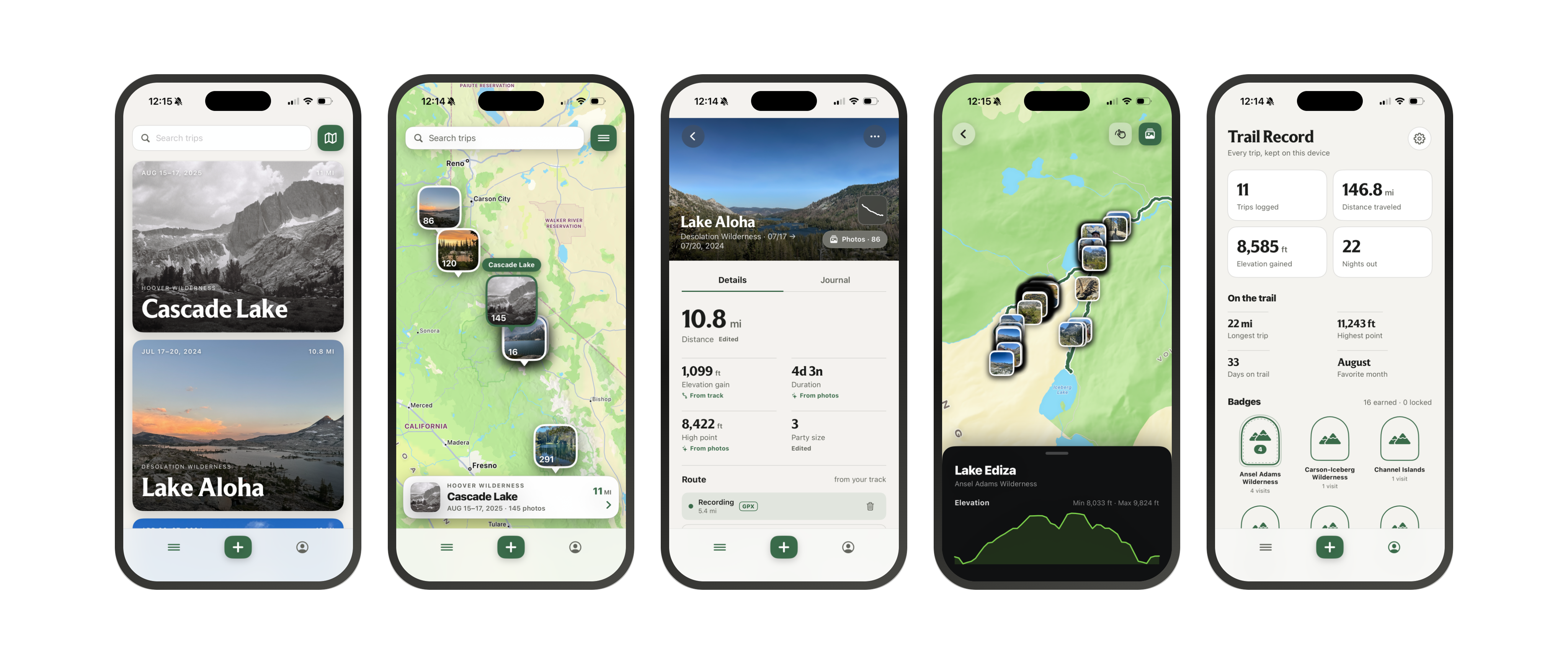
Monolog started from a personal need
Founder, designer, developer
Role
2026
Year
iOS
SwiftUI, MapLibre Native, GPX import. No account, no server, no data collection.
Before I built Monolog, I would reflect on my trips solo backpacking, or trips with my friends or my fiancée and while I had ways to view the photos, the rest would get lost in the archives of my life. The options available almost required me to have a social presence, and the data collection happening everywhere gave me pause as to who I would give my photos to. I decided to build Monolog to fill that gap, and to let people remember and enjoy their memories without worrying about where their photos were being stored.
The question behind it has always been: what does a record of a trip actually need to contain, and what can it leave out?
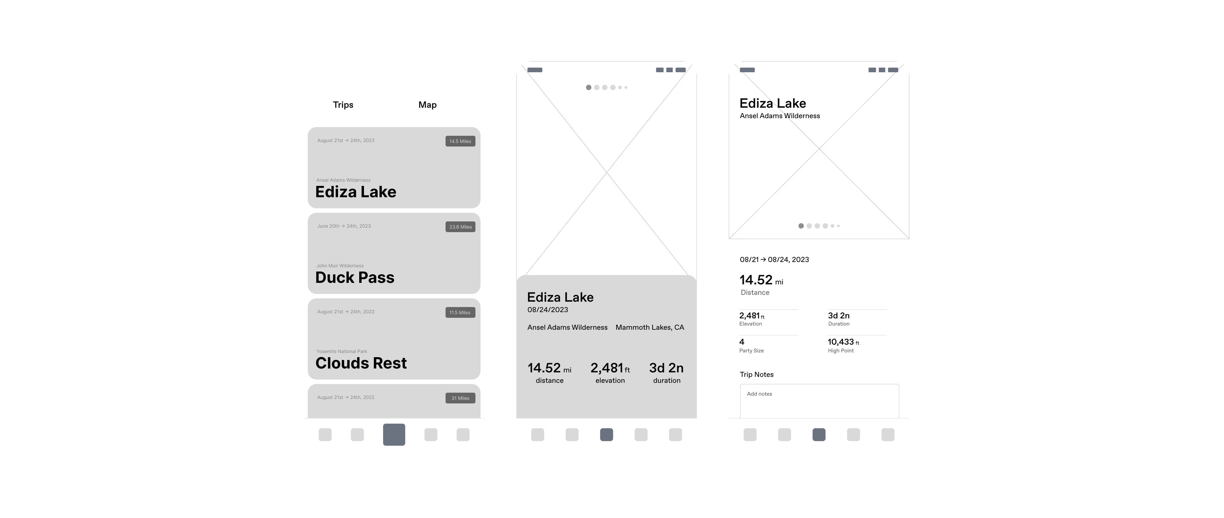
Starting from the camera roll
Most people already keep a record of their trips. It’s just in Photos, mixed in with everything else, with no way to see a trip as a trip.
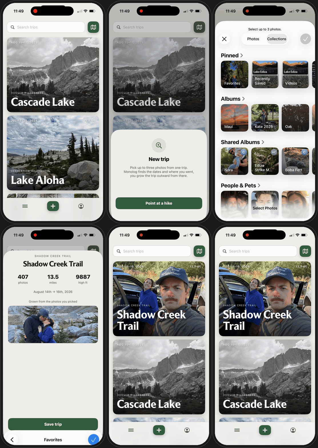
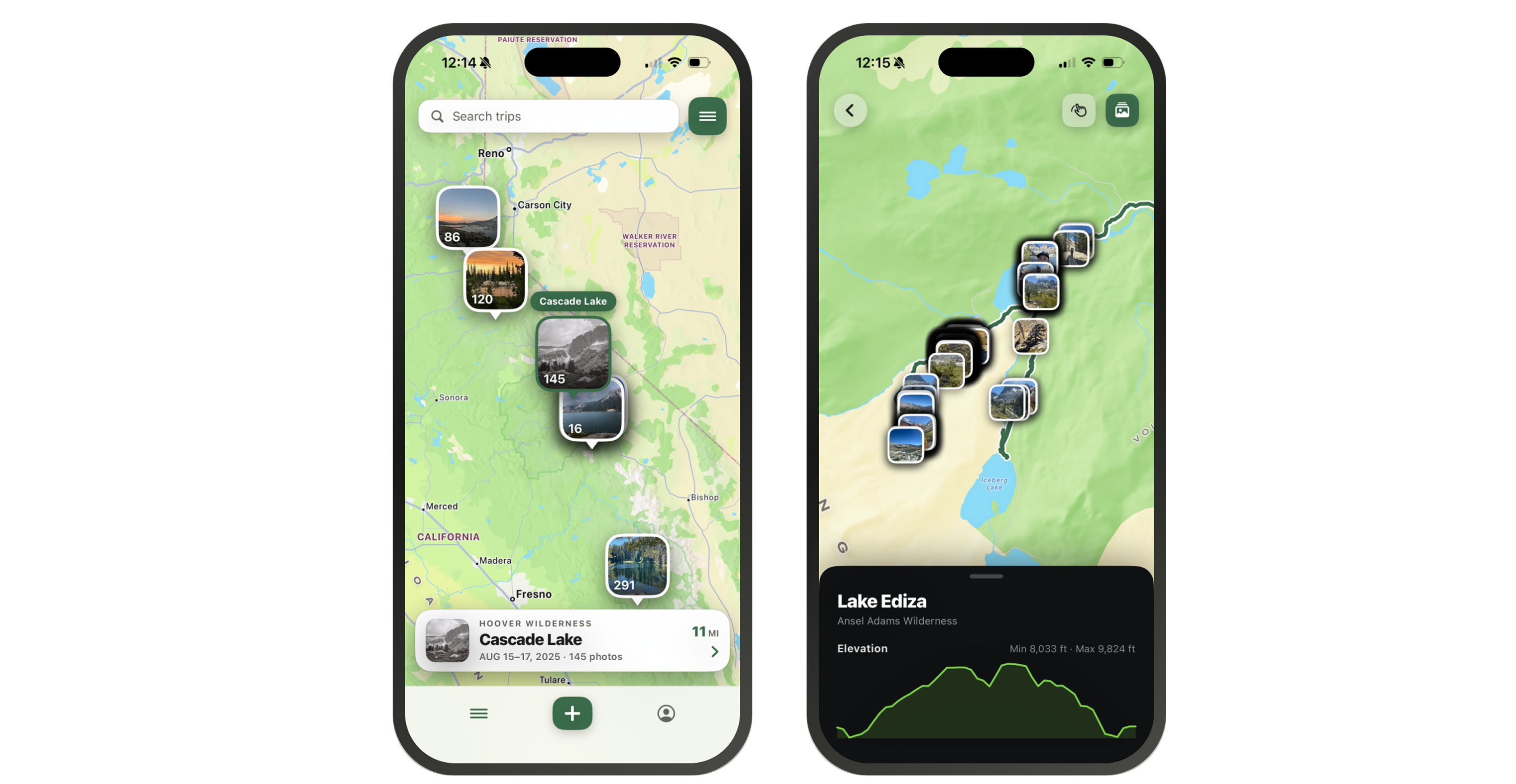
That was the insight Monolog is built on. A photo taken in the backcountry carries a timestamp and, usually, a location. A day’s worth of them is a trail log that nobody ever assembled. So instead of asking you to remember to start a recording at the trailhead, Monolog starts from the photos and builds outward.
You hand it a photo or two from your camera roll and it detects the trip on its own, clustering photos taken close together in time and place into a single entry. You don’t create a trip; you open the app and find that it’s already there. The best part is that all of this stays local to your device, nothing is stored or shared on Monolog’s end.
Without a GPS track, a trip is exactly what the photos can prove: each one placed as a point on a topo map, in the order you took them. No invented line between them. If Monolog didn’t see you walk it, it doesn’t draw it.
When you do have a track (from a watch, a Garmin, Gaia, or whatever recorded it) you import the file and the route becomes the second layer. The photos stay where they were; the line and its stats sit underneath them.
This ordering mattered more than any single screen. It means a trip you forgot to record still exists in Monolog, and one you did record is richer, not different.
Choosing the map
Because Monolog places photos and draws routes instead of navigating, the map is doing a different job than in most outdoor apps. It’s a background for a record, not a tool for a decision.
I evaluated MapKit against MapLibre Native and chose MapLibre with a topo tile source. In short, I biased toward MapLibre because topographic detail matters for backcountry terrain and MapKit’s default styling doesn’t read as a trail map.
The trip entry
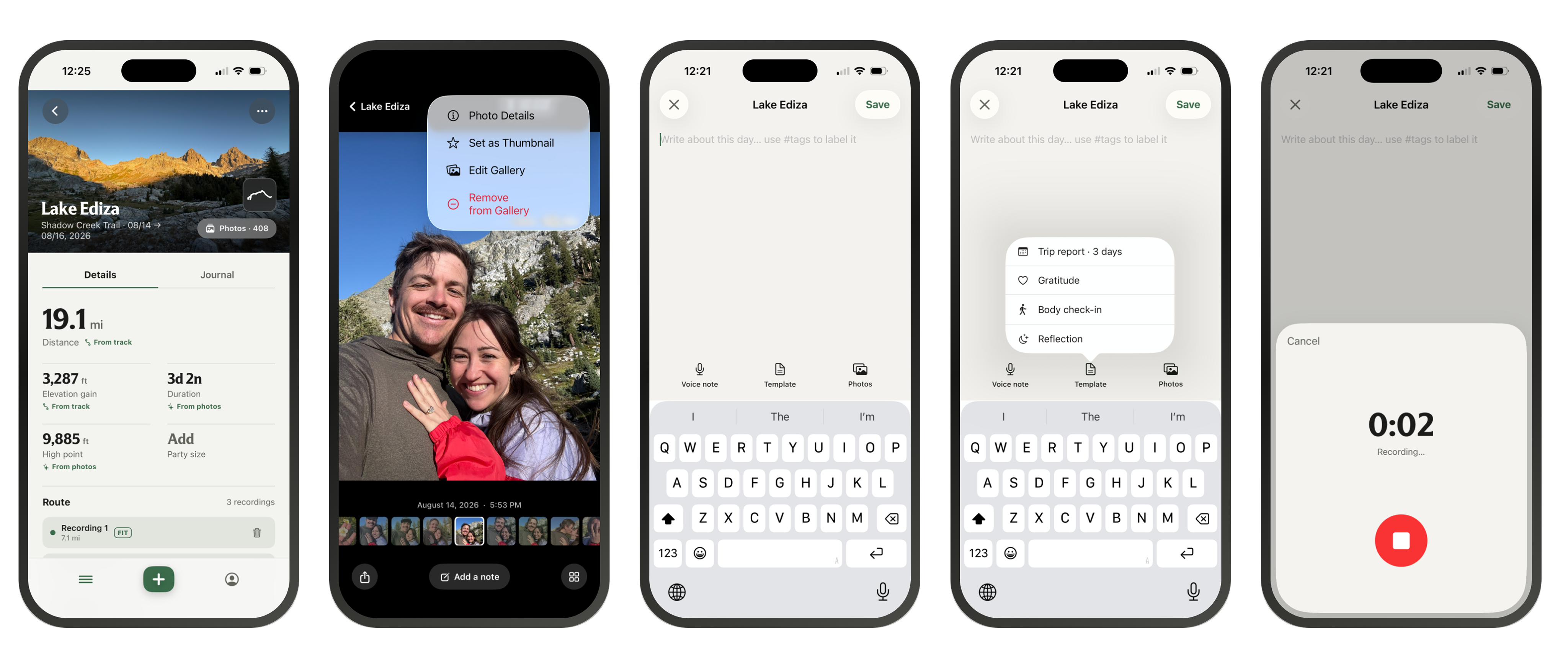
Everything a trip entry is made of already exists before you open the app: the photos, the trackpoints, the notes you jotted somewhere. The work was making the assembly the easy part.
Point Monolog at a photo or two from the trip and it finds every photo taken in the same place, in the same stretch of time, and gathers them into one entry. You don’t sort, tag, or drag anything. The trip is there before you’ve decided what to call it.
That’s the point where the app steps back and you step in. Who you were with. What you noticed. What you were thinking about on the way up, or what you figured out about yourself on the way down. A trip entry has room for as much of that as you want to give it, and none of it is required.
The entry also carries the record: how far you went, how much you climbed, how hard it was. Just to remember, not to compete with anyone.
The result is a record of your favorite trips that took almost no effort to build and holds everything you cared about keeping.
Getting the numbers right
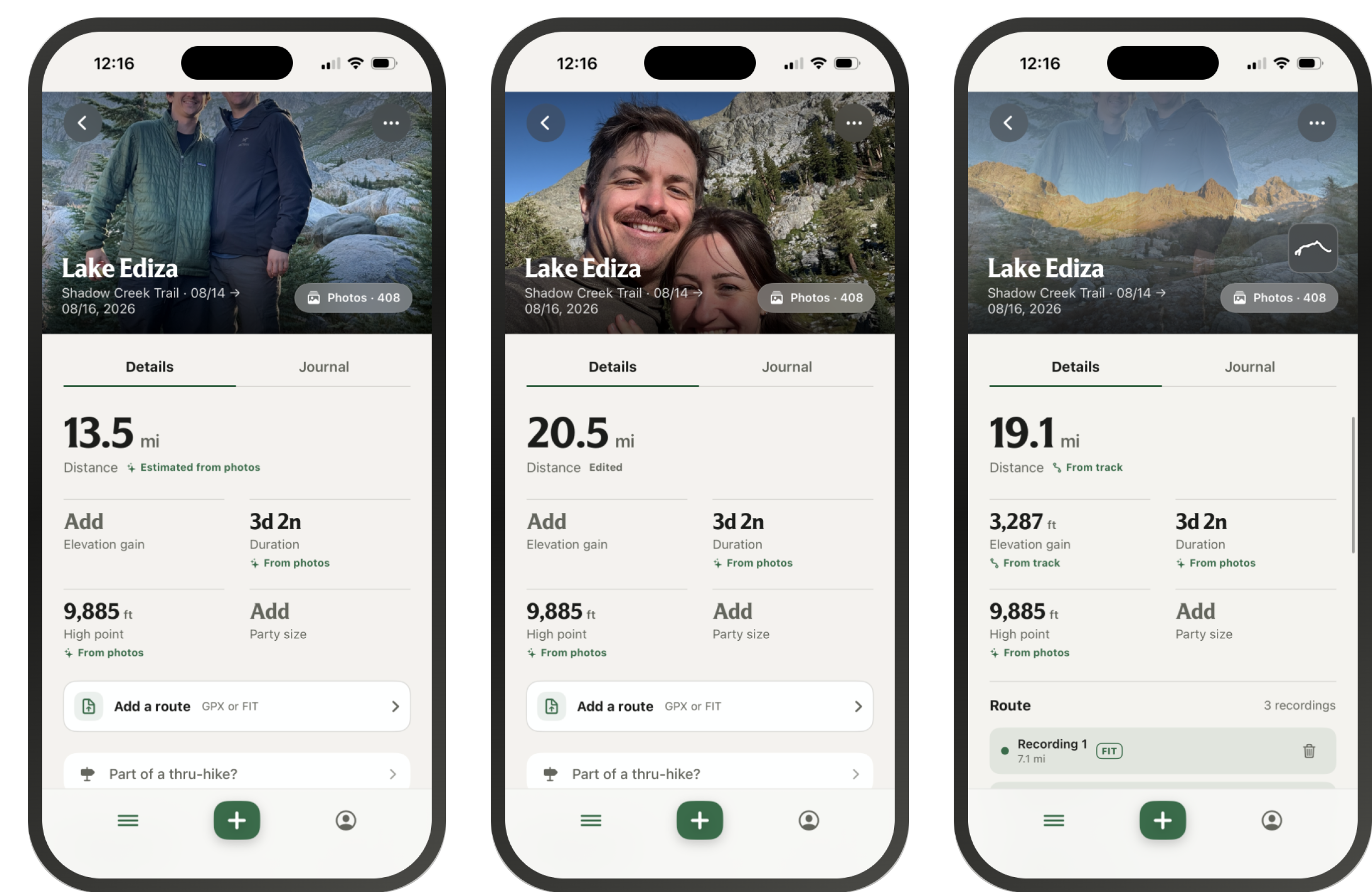
A trip record is only trustworthy if the numbers are, and Monolog starts with less than most apps to compute them from. There’s no track by default, just photos with a location and a time.
So the first estimate comes from the photos themselves. Monolog measures the distance between where each photo was taken, in order, and that becomes the trip’s starting figure. It’s honest about what it is: a floor, not a measurement. If you walked three miles between two photos, the app doesn’t know, and it doesn’t pretend to.
From there you have two ways to get closer to the truth. You can correct the number by hand or you can import a track from whatever recorded it and let the real data replace the estimate.
That order was a deliberate choice. A guess labeled as a guess is more useful than a confident number that’s wrong, and it means a trip you never recorded still gets a record instead of a blank.
Knowing what not to add
There was one thing I committed to from the very beginning: no data collection, no account, no password. My goal was to create a tool that benefits people and their interests, not one that collects information to sell later. These memories are theirs to keep, I just wanted to give them a better tool to access and document each one.
That commitment settled a lot of other questions before I had to ask them. Social sharing has become standard in outdoor apps: feeds, kudos, public activity maps. All of which runs on accounts and servers holding your data. Leaving accounts out meant leaving that out too, and I was fine with the trade. A log is for the person who lived the trip. The moment it’s built to be seen by other people, it starts getting shaped for them, which photo should I post, was this hike long enough or are the routes worth posting? Monolog is for the trips you’d keep even if no one else ever saw them.
It also meant no sign-up wall. Too many accounts and passwords are a real barrier, for me as much as anyone, and I didn’t want the first thing Monolog asked for to be a password. You open it, and your trips are there.
What Monolog taught me
Monolog is, ultimately, a fancy photo album.
But that’s exactly what makes it a good design project.
It’s a reminder that the least ambitious version of something is often the one worth building carefully. An outdoor app can be loud, social, extractive, always pointing you toward the next trip. Or it can be quiet, private, and content to hold onto the one you just took. The difference lives entirely in what you decide it’s for.
Monolog looks simple on the surface, but there’s a lot underneath: the way a trip assembles itself from photos you already took, the way the map only draws what it can prove, the way a GPS track adds to a record without replacing it, and the way the whole thing runs without an account, a password, or a single byte of your data leaving the phone.
My goal was never to make the backcountry more shareable, or more measurable.
The goal was to give people a better way to keep what they did out there without getting in the way, asking for anything in return, or turning their own memories into something that belongs to someone else.
That’s what I want Monolog to be: private, honest, and built for you.